Geolocate

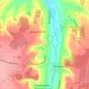
Ussy topographic map

Click on the map to display elevation.

About this map

Name: Ussy topographic map, elevation, terrain.

Location: Ussy, Caen, Calvados, Normandy, Metropolitan France, 14420, France (48.92863 -0.31667 48.96291 -0.26439)

Average elevation: 171 m

Minimum elevation: 122 m

Maximum elevation: 205 m

Other topographic maps

Click on a map to view its topography, its elevation and its terrain.
Omaha Beach

France > Normandy > Calvados > Vierville-sur-Mer

Average elevation: 21 m

Cour Philippin

France > Normandy > Calvados > Livarot-Pays-d'Auge

Average elevation: 136 m

Gear up for your next adventure:

🛌Insulated Sleeping Pad - Critical thermal barrier between you and the cold ground
🥤Collapsible Travel Cup - Saves space and weight in your mess kit
⛺Camping Tent - Weather-resistant tents suitable for 2 to 6 people
🥾Hiking Shoes - Durable and comfortable shoes for trail hiking
🥽Outdoor Goggles - Protective eyewear for outdoor activities

As an Amazon Associate, this site earns from qualifying purchases at no extra cost to you.