Geolocate

Natharkui topographic map

Click on the map to display elevation.

About this map

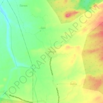
Name: Natharkui topographic map, elevation, terrain.

Location: Natharkui, Bhuj Taluka, Kachchh, Gujarat, 370675, India (23.29842 69.44436 23.33842 69.48436)

Average elevation: 122 m

Minimum elevation: 83 m

Maximum elevation: 165 m

Other topographic maps

Click on a map to view its topography, its elevation and its terrain.

Baladiya

India > Gujarat > Bhuj Taluka

Average elevation: 153 m

Luna crater

India > Gujarat > Bhuj Taluka

Average elevation: 4 m

Bhuj Taluka

India > Gujarat > Bhuj Taluka

Average elevation: 46 m

Gear up for your next adventure:

🧴Sunscreen SPF - Broad-spectrum sunscreen for outdoor activities
💡Solar Camping Lamp - Eco-friendly lighting for campsites
🎒Hiking Backpack - Lightweight and ergonomic backpacks for day hikes or multi-day treks
🥾Mountain Hiking Shoes - Shoes with superior grip for mountainous terrain
🪜Heavy Duty Carabiners - Multi-use clips for securing gear to your backpack

As an Amazon Associate, this site earns from qualifying purchases at no extra cost to you.