Geolocate

Monte Perdido topographic map

Click on the map to display elevation.

About this map

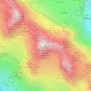
Name: Monte Perdido topographic map, elevation, terrain.

Location: Monte Perdido, Bielsa, Sobrarbe, Huesca, Aragón, España (42.67552 0.03442 42.67562 0.03452)

Average elevation: 2,807 m

Minimum elevation: 2,152 m

Maximum elevation: 3,341 m

Other topographic maps

Click on a map to view its topography, its elevation and its terrain.

Lago de Marboré

España > Aragón > Bielsa

Average elevation: 2,508 m

Gear up for your next adventure:

🔪Outdoor Multitool - Versatile tool for repairs and food prep in the wild
🥽Outdoor Goggles - Protective eyewear for outdoor activities
🧳Compression Sacks - Maximize space in your backpack by shrinking gear
🔋Lithium AA Batteries - Long-lasting power that performs in extreme cold
🥾Hiking Shorts - Breathable shorts suitable for summer hikes

As an Amazon Associate, this site earns from qualifying purchases at no extra cost to you.