
Make a donation
Gear up for your next adventure:
As an Amazon Associate, this site earns from qualifying purchases at no extra cost to you.
Namakkal topographic map
Click on the map to display elevation.
Make a donation
Gear up for your next adventure:
As an Amazon Associate, this site earns from qualifying purchases at no extra cost to you.
Namakkal
Namakkal is located at 11°14′N 78°10′E / 11.23°N 78.17°E / 11.23; 78.17. It has an average elevation of 218 metres or 715 feet. It is close to Kolli Hills – which are part of the Eastern Ghats. The closest significant river is the Kaveri and it is located 360 kilometres or 224 miles southwest of Chennai and 250 kilometres or 155 miles south of Bangalore.
Make a donation
Gear up for your next adventure:
As an Amazon Associate, this site earns from qualifying purchases at no extra cost to you.
About this map
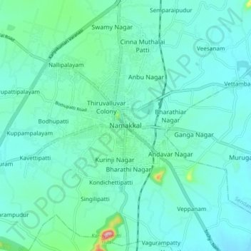
Name: Namakkal topographic map, elevation, terrain.
Location: Namakkal, Namakkal District, Tamil Nadu, 637001, India (11.17917 78.12787 11.25917 78.20787)
Average elevation: 192 m
Minimum elevation: 163 m
Maximum elevation: 354 m
Make a donation
Gear up for your next adventure:
As an Amazon Associate, this site earns from qualifying purchases at no extra cost to you.