
Make a donation
Gear up for your next adventure:
As an Amazon Associate, this site earns from qualifying purchases at no extra cost to you.
Damariscotta topographic map
Click on the map to display elevation.
Make a donation
Gear up for your next adventure:
As an Amazon Associate, this site earns from qualifying purchases at no extra cost to you.
Damariscotta
According to the United States Census Bureau, the town has a total area of 14.71 square miles (38.10 km2), of which 12.42 square miles (32.17 km2) is land and 2.29 square miles (5.93 km2) is water. Damariscotta is situated on the Damariscotta River, a tidal estuary of the Gulf of Maine. Hunt Hill, at an elevation of 350 feet (108 m) above sea level, is the town's highest point.
Make a donation
Gear up for your next adventure:
As an Amazon Associate, this site earns from qualifying purchases at no extra cost to you.
About this map
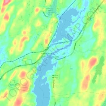
Name: Damariscotta topographic map, elevation, terrain.
Location: Damariscotta, Lincoln County, Maine, 04543, United States (44.00432 -69.54519 44.06615 -69.44345)
Average elevation: 29 m
Minimum elevation: -4 m
Maximum elevation: 88 m
Make a donation
Gear up for your next adventure:
As an Amazon Associate, this site earns from qualifying purchases at no extra cost to you.
Other topographic maps
Click on a map to view its topography, its elevation and its terrain.