Geolocate

Seabrook topographic map

Interactive map

Click on the map to display elevation.

About this map

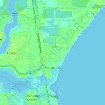
Name: Seabrook topographic map, elevation, terrain.

Location: Seabrook, Harris County, Texas, 77586, United States (29.54745 -95.05014 29.59473 -94.98692)

Average elevation: 3 m

Minimum elevation: -4 m

Maximum elevation: 12 m

Other topographic maps

Click on a map to view its topography, its elevation and its terrain.

Cypress

United States > Texas > Harris County

Average elevation: 46 m

Bellaire

United States > Texas > Harris County

Average elevation: 20 m

Baytown

United States > Texas > Harris County

Average elevation: 7 m

La Porte

United States > Texas > Harris County

Average elevation: 4 m

Houston

United States > Texas > Harris County

Much of the city was built on forested land, marshes, or swamps, and all are still visible in surrounding areas. Flat terrain and extensive greenfield development have combined to worsen flooding. Downtown stands about 50 feet (15 m) above sea level, and the highest point in far northwest Houston is about 150…

Average elevation: 25 m

Memorial Park

United States > Texas > Harris County > Houston

Average elevation: 21 m

Pasadena

United States > Texas > Harris County

Average elevation: 11 m

Spring Valley

United States > Texas > Harris County

Average elevation: 25 m

Spring

United States > Texas > Harris County

Average elevation: 35 m