
Make a donation
Gear up for your next adventure:
As an Amazon Associate, this site earns from qualifying purchases at no extra cost to you.
São Bernardo do Campo topographic map
Click on the map to display elevation.
Make a donation
Gear up for your next adventure:
As an Amazon Associate, this site earns from qualifying purchases at no extra cost to you.
São Bernardo do Campo
São Bernardo do Campo is located in the top of the Serra do Mar, on the Atlantic plateau. It occupies an area of 407.1 square kilometre. The altitude varies from a low of 60 meters above sea level at the foot of the mountain range where Rio Passareúva with the Rio Pilões rivers meet, to 986.5 meters at the peak of the Bonilha, in the Montanhão neighborhood.
Make a donation
Gear up for your next adventure:
As an Amazon Associate, this site earns from qualifying purchases at no extra cost to you.
About this map
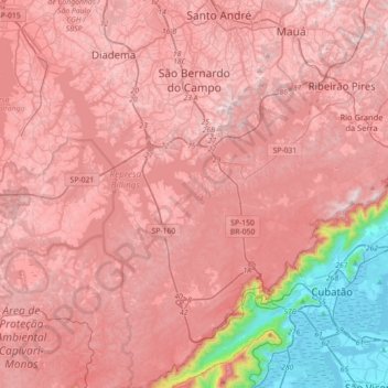
Name: São Bernardo do Campo topographic map, elevation, terrain.
Average elevation: 665 m
Minimum elevation: -3 m
Maximum elevation: 954 m
Make a donation
Gear up for your next adventure:
As an Amazon Associate, this site earns from qualifying purchases at no extra cost to you.
Other topographic maps
Click on a map to view its topography, its elevation and its terrain.
Jardim Copacabana
Brazil > São Paulo > Região Metropolitana de São Paulo > São Paulo
Average elevation: 792 m