Make a donation
Gear up for your next adventure:
As an Amazon Associate, this site earns from qualifying purchases at no extra cost to you.
Lancaster topographic map
Click on the map to display elevation.
Make a donation
Gear up for your next adventure:
As an Amazon Associate, this site earns from qualifying purchases at no extra cost to you.
About this map
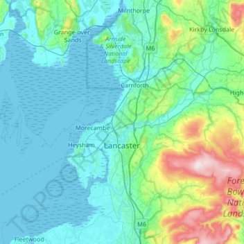
Name: Lancaster topographic map, elevation, terrain.
Location: Lancaster, Lancashire, England, United Kingdom (53.91807 -2.98365 54.23956 -2.45873)
Average elevation: 84 m
Minimum elevation: 0 m
Maximum elevation: 561 m
Make a donation
Gear up for your next adventure:
As an Amazon Associate, this site earns from qualifying purchases at no extra cost to you.
Other topographic maps
Click on a map to view its topography, its elevation and its terrain.
Lytham St Annes
United Kingdom > England > Lancashire > Fylde > Lytham St Annes
Average elevation: 5 m
Make a donation
Gear up for your next adventure:
As an Amazon Associate, this site earns from qualifying purchases at no extra cost to you.
