
Make a donation
Gear up for your next adventure:
As an Amazon Associate, this site earns from qualifying purchases at no extra cost to you.
Cachan topographic map
Click on the map to display elevation.
Make a donation
Gear up for your next adventure:
As an Amazon Associate, this site earns from qualifying purchases at no extra cost to you.
Cachan
La commune située dans la vallée de la Bièvre entre le plateau de Longboyau à l'est et celui de Châtillon à l'ouest a une superficie de 2,7 km2, une altitude minimum de 42 mètres, maximum de 111 mètres. Son territoire fait partie du bassin parisien formé à l'époque tertiaire.
Make a donation
Gear up for your next adventure:
As an Amazon Associate, this site earns from qualifying purchases at no extra cost to you.
About this map
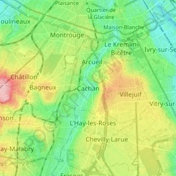
Name: Cachan topographic map, elevation, terrain.
Average elevation: 78 m
Minimum elevation: 26 m
Maximum elevation: 170 m
Make a donation
Gear up for your next adventure:
As an Amazon Associate, this site earns from qualifying purchases at no extra cost to you.