
Talcahuano topographic map
Click on the map to display elevation.
About this map
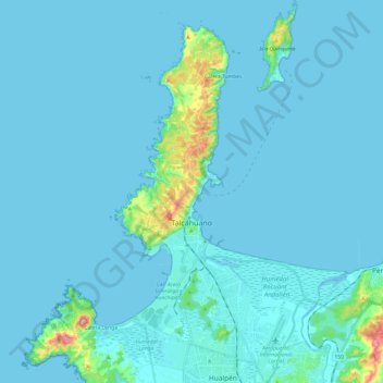
Name: Talcahuano topographic map, elevation, terrain.
Location: Talcahuano, Provincia de Concepción, Biobio Region, Chile (-36.79553 -73.16564 -36.60194 -73.01568)
Average elevation: 16 m
Minimum elevation: 0 m
Maximum elevation: 237 m
Other topographic maps
Click on a map to view its topography, its elevation and its terrain.
Agua de la Gloria
Chile > Biobío Region > Provincia de Concepción > Concepcion > El Pino
Average elevation: 94 m
Casa Poli
Chile > Biobío Region > Provincia de Concepción > Dichato > Camino a Los Cerezos Bajo
Average elevation: 27 m