
Make a donation
Gear up for your next adventure:
As an Amazon Associate, this site earns from qualifying purchases at no extra cost to you.
Döllberg topographic map
Click on the map to display elevation.
Make a donation
Gear up for your next adventure:
As an Amazon Associate, this site earns from qualifying purchases at no extra cost to you.
About this map
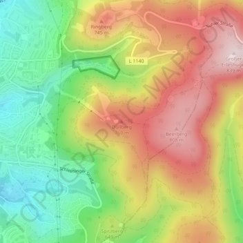
Name: Döllberg topographic map, elevation, terrain.
Location: Döllberg, Suhl, Thüringen, 98527, Deutschland (50.60526 10.72548 50.60536 10.72558)
Average elevation: 640 m
Minimum elevation: 455 m
Maximum elevation: 834 m
Make a donation
Gear up for your next adventure:
As an Amazon Associate, this site earns from qualifying purchases at no extra cost to you.
Other topographic maps
Click on a map to view its topography, its elevation and its terrain.
Schmiedefeld am Rennsteig
Deutschland > Thüringen > Suhl
Der Ort wurde 1406 erstmals urkundlich uf dem Smidfeldt erwähnt, somit geht die Ortsgründung auf die Gewinnung und Weiterverarbeitung von Eisenerz zurück. Der Ort zählte im Mittelalter zum Herrschaftsgebiet der Grafen von Henneberg, was auch im Ortswappen zu erkennen ist. Die noch kleine Siedlung befand…
Average elevation: 747 m
Gehlberg
Deutschland > Thüringen > Suhl
Gehlberg liegt am Nordhang des Thüringer Waldes auf einer Hochfläche zwischen den Tälern von Wilder und Zahmer Gera im Thüringer Wald. Der Ort erstreckt sich von etwa 680 bis 750 Metern Höhe. Der vom restlichen Dorf getrennte Ortsteil Gehlberger Grund liegt auf etwa 600 Metern Höhe im Tal des Langen…
Average elevation: 757 m
Make a donation
Gear up for your next adventure:
As an Amazon Associate, this site earns from qualifying purchases at no extra cost to you.