Geolocate

200m topographic map

Click on the map to display elevation.

About this map

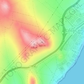
Name: 200m topographic map, elevation, terrain.

Location: 200m, Pájara, Las Palmas, Canary Islands, ES35627, Spain (28.15696 -14.24226 28.15706 -14.24216)

Average elevation: 87 m

Minimum elevation: 0 m

Maximum elevation: 194 m

Gear up for your next adventure:

🔭Compact Monocular - One-handed bird watching and trail spotting
🥾All-Terrain Hiking Boots - Versatile boots for varied hiking conditions
🦟Insect Repellent - Keep mosquitoes and black flies away in wooded areas
🎒Fully Waterproof Backpack - Total protection for photography gear and electronics
🪑Ultralight Camping Stool - Compact seating for rest stops during long hikes

As an Amazon Associate, this site earns from qualifying purchases at no extra cost to you.