
Donat topographic map
Click on the map to display elevation.
About this map
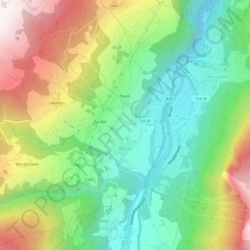
Name: Donat topographic map, elevation, terrain.
Location: Donat, Muntogna da Schons, Viamala, Grisons, Switzerland (46.61333 9.39960 46.65226 9.44581)
Average elevation: 1,318 m
Minimum elevation: 868 m
Maximum elevation: 2,049 m
Other topographic maps
Click on a map to view its topography, its elevation and its terrain.
Mathon
Switzerland > Grisons > Viamala > Muntogna da Schons > Donat
Before 2017, the former municipality was located in the Schams sub-district, of the Hinterrhein district, after 2017 it was part of the Viamala Region. The village is a haufendorf (an irregular, unplanned and quite closely packed village, built around a central square) at an elevation of 1,521 m (4,990 ft) in…
Average elevation: 1,520 m