Geolocate

Warren topographic map

Click on the map to display elevation.

About this map

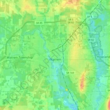
Name: Warren topographic map, elevation, terrain.

Location: Warren, Trumbull County, Ohio, United States (41.21086 -80.89400 41.27205 -80.74052)

Average elevation: 277 m

Minimum elevation: 257 m

Maximum elevation: 324 m

Other topographic maps

Click on a map to view its topography, its elevation and its terrain.

Vienna

United States > Ohio > Trumbull County

Average elevation: 342 m

Howland Township

United States > Ohio > Trumbull County

Average elevation: 299 m

Vienna Township

United States > Ohio > Trumbull County

Average elevation: 342 m

Burghill

United States > Ohio > Trumbull County > Vernon Township

Average elevation: 311 m

Gear up for your next adventure:

🧥Packable Rain Jacket - Breathable waterproof layer for unpredictable weather
🔋Emergency Crank Radio - Weather alerts and power without needing batteries
🎒Backpack Rain Cover - External shield to keep your entire pack dry
🥾Waterproof Hiking Boots - Boots keeping your feet dry in wet conditions
🎒Fully Waterproof Backpack - Total protection for photography gear and electronics

As an Amazon Associate, this site earns from qualifying purchases at no extra cost to you.