Geolocate

Ungale topographic map

Click on the map to display elevation.

About this map

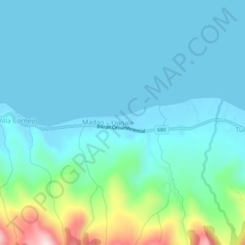
Name: Ungale topographic map, elevation, terrain.

Location: Ungale, Biliran, Eastern Visayas, Philippines (11.68189 124.42926 11.72189 124.46926)

Average elevation: 67 m

Minimum elevation: -1 m

Maximum elevation: 402 m

Other topographic maps

Click on a map to view its topography, its elevation and its terrain.

Biliran

Philippines > Biliran

Average elevation: 170 m

Maripipi

Philippines > Biliran

Average elevation: 52 m

Sambawan Islands

Philippines > Biliran > Maripipi

Average elevation: 0 m

Biliran

Philippines > Biliran

Average elevation: 170 m

Gear up for your next adventure:

🧥Thermal Fleece Jacket - Versatile insulation for changing mountain temperatures
🪑Ultralight Camping Stool - Compact seating for rest stops during long hikes
🧊Portable Cooler - Keep food and drinks cold during outdoor adventures
🧢Sun Hat - Wide-brim hat for sun protection
🚲MTB Frame Bag - Carry tools and maps directly on your bicycle frame

As an Amazon Associate, this site earns from qualifying purchases at no extra cost to you.