Geolocate

Bompas topographic map

Click on the map to display elevation.

About this map
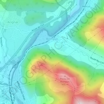
Name: Bompas topographic map, elevation, terrain.

Location: Bompas, Foix, Ariège, Occitania, Metropolitan France, 09400, France (42.85333 1.60413 42.87209 1.63342)

Average elevation: 582 m

Minimum elevation: 453 m

Maximum elevation: 925 m

Other topographic maps

Click on a map to view its topography, its elevation and its terrain.
Cazenave

France > Occitania > Ariège

Average elevation: 1,089 m

Rufat

France > Occitania > Ariège > Ax-les-Thermes

Average elevation: 994 m

Rémous

France > Occitania > Ariège > Auzat

Average elevation: 1,502 m

Le Pujal

France > Occitania > Ariège > Ascou

Average elevation: 1,380 m

1694

France > Occitania > Ariège > Bethmale

Average elevation: 1,566 m

Gear up for your next adventure:

🧥Thermal Fleece Jacket - Versatile insulation for changing mountain temperatures
🧤Insulated Winter Gloves - Heavy-duty protection for sub-zero Canadian adventures
🥾Hiking Leggings - Comfortable leggings for outdoor activities
💡Compact LED Flashlight - Powerful and portable flashlight for outdoor use
🥾Trail Hiking Boots - Supportive boots for rough trails

As an Amazon Associate, this site earns from qualifying purchases at no extra cost to you.