
Make a donation
Gear up for your next adventure:
As an Amazon Associate, this site earns from qualifying purchases at no extra cost to you.
Gernewitz topographic map
Click on the map to display elevation.
Make a donation
Gear up for your next adventure:
As an Amazon Associate, this site earns from qualifying purchases at no extra cost to you.
About this map
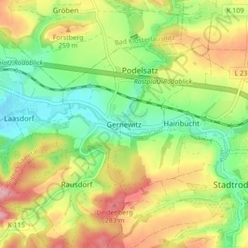
Name: Gernewitz topographic map, elevation, terrain.
Average elevation: 226 m
Minimum elevation: 167 m
Maximum elevation: 301 m
Make a donation
Gear up for your next adventure:
As an Amazon Associate, this site earns from qualifying purchases at no extra cost to you.
Other topographic maps
Click on a map to view its topography, its elevation and its terrain.
Quirla
Deutschland > Thüringen > Saale-Holzland-Kreis > Stadtroda
Der Jahresniederschlag beträgt 584 mm. Die Niederschläge sind niedrig. Sie liegen im unteren Viertel der in Deutschland erfassten Werte. An 18 % der Messstationen werden niedrigere Werte registriert. Der trockenste Monat ist der Februar, die meisten Niederschläge fallen im Juni. Im Juni fallen 2,4 mal mehr…
Average elevation: 282 m