
Make a donation
Gear up for your next adventure:
As an Amazon Associate, this site earns from qualifying purchases at no extra cost to you.
Gaislachkogel topographic map
Click on the map to display elevation.
Make a donation
Gear up for your next adventure:
As an Amazon Associate, this site earns from qualifying purchases at no extra cost to you.
Gaislachkogel
Der Gaislachkogel (auch Hinterer Geislachkogel, Gaislacher Kogel oder Geislacher Kogel) ist ein 3056 m ü. A. hoher Berg in den Ötztaler Alpen in Tirol, Österreich. Er befindet sich westlich von Sölden im Ötztal und nördlich des Venter Tals. Der nächsthöhere Berg ist die Äußere Schwarze Schneid (3255 m), die in 2,5 Stunden über den westlichen Grat erreicht werden kann. Südöstlich ist der 2982 m hohe Vordere Geislachkogel vorgelagert.
Make a donation
Gear up for your next adventure:
As an Amazon Associate, this site earns from qualifying purchases at no extra cost to you.
About this map
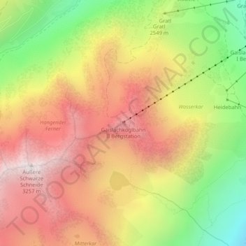
Name: Gaislachkogel topographic map, elevation, terrain.
Average elevation: 2,620 m
Minimum elevation: 1,913 m
Maximum elevation: 3,215 m
Make a donation
Gear up for your next adventure:
As an Amazon Associate, this site earns from qualifying purchases at no extra cost to you.
Other topographic maps
Click on a map to view its topography, its elevation and its terrain.
Ramolhaus
Österreich > Tirol > Bezirk Imst > Gemeinde Sölden
Der Aufstieg erfolgt von Obergurgl (1927 m) auf dem bezeichneten Weitwanderweg Nr. 902 in einer Gehzeit von vier Stunden. In Obergurgl wird zunächst die Gurgler Ache in südwestlicher Richtung überquert. Der Weg führt zunächst am westlichen Talhang in zwei Kehren empor, quert dann einen Bach und führt…
Average elevation: 2,855 m