
Make a donation
Gear up for your next adventure:
As an Amazon Associate, this site earns from qualifying purchases at no extra cost to you.
Abeto topographic map
Click on the map to display elevation.
Make a donation
Gear up for your next adventure:
As an Amazon Associate, this site earns from qualifying purchases at no extra cost to you.
Abeto
Il paese si trova ad un'altitudine di 970 m s.l.m., a circa 8 km a sud di Preci e 11 km a nord di Norcia, ai confini del Parco Nazionale dei Monti Sibillini. gli abitanti sono 4 (abetani).
Make a donation
Gear up for your next adventure:
As an Amazon Associate, this site earns from qualifying purchases at no extra cost to you.
About this map
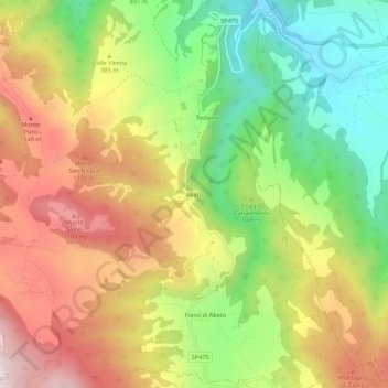
Name: Abeto topographic map, elevation, terrain.
Location: Abeto, Preci, Perugia, Umbria, 06047, Italia (42.81697 13.04354 42.85697 13.08354)
Average elevation: 949 m
Minimum elevation: 650 m
Maximum elevation: 1,276 m
Make a donation
Gear up for your next adventure:
As an Amazon Associate, this site earns from qualifying purchases at no extra cost to you.