
Thank you for supporting this site ❤️
Make a donation
Make a donation
Gear up for your next adventure:
As an Amazon Associate, this site earns from qualifying purchases at no extra cost to you.
Tarn-et-Garonne topographic map
Click on the map to display elevation.
Thank you for supporting this site ❤️
Make a donation
Make a donation
Gear up for your next adventure:
As an Amazon Associate, this site earns from qualifying purchases at no extra cost to you.
About this map
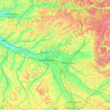
Name: Tarn-et-Garonne topographic map, elevation, terrain.
Location: Tarn-et-Garonne, Occitania, Metropolitan France, France (43.76743 0.73781 44.39389 2.00090)
Average elevation: 172 m
Minimum elevation: 36 m
Maximum elevation: 520 m
Thank you for supporting this site ❤️
Make a donation
Make a donation
Gear up for your next adventure:
As an Amazon Associate, this site earns from qualifying purchases at no extra cost to you.
Other topographic maps
Click on a map to view its topography, its elevation and its terrain.
Saint-Hyppolyte
France > Occitania > Tarn-et-Garonne > Bouloc-en-Quercy > Bouloc > Saint-Hyppolyte
Average elevation: 176 m