Geolocate

Swan topographic map

Click on the map to display elevation.

About this map

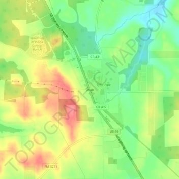
Name: Swan topographic map, elevation, terrain.

Location: Swan, Smith County, Texas, 75606, United States (32.41487 -95.38718 32.45487 -95.34718)

Average elevation: 156 m

Minimum elevation: 119 m

Maximum elevation: 196 m

Gear up for your next adventure:

💡LED Headlamp - Hands-free illumination for night hiking and camping
🥤Collapsible Travel Cup - Saves space and weight in your mess kit
🎒Hiking Daypack - Lightweight and durable backpacks for day trips and excursions
🧢Hiking Hat - Sun-protective and breathable hats for long treks
🧰Multitool Knife - Compact and versatile tool for outdoor use

As an Amazon Associate, this site earns from qualifying purchases at no extra cost to you.