
Make a donation
Gear up for your next adventure:
As an Amazon Associate, this site earns from qualifying purchases at no extra cost to you.
Ifrane topographic map
Click on the map to display elevation.
Make a donation
Gear up for your next adventure:
As an Amazon Associate, this site earns from qualifying purchases at no extra cost to you.
Ifrane
Ifrane (Arabic: إفران) is a city in the Middle Atlas region of northern Morocco (population 14,659 as of November 2014). The capital of Ifrane Province in the region of Fès-Meknès, Ifrane is located at an elevation of 1,665 m (5,463 ft). In the regional Tamazight language, "ifran" means caves.
Make a donation
Gear up for your next adventure:
As an Amazon Associate, this site earns from qualifying purchases at no extra cost to you.
About this map
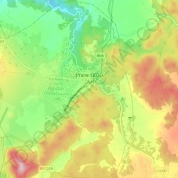
Name: Ifrane topographic map, elevation, terrain.
Average elevation: 1,668 m
Minimum elevation: 1,534 m
Maximum elevation: 1,838 m
Make a donation
Gear up for your next adventure:
As an Amazon Associate, this site earns from qualifying purchases at no extra cost to you.