Geolocate

Bosost topographic map

Click on the map to display elevation.

About this map

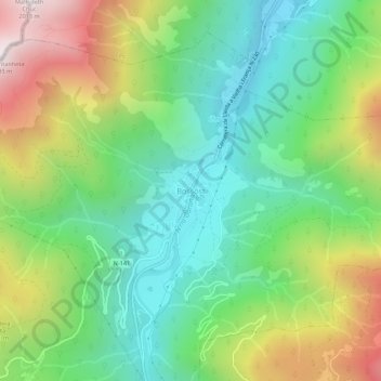
Name: Bosost topographic map, elevation, terrain.

Location: Bosost, Bossòst, Valle de Arán, Lérida, Cataluña, 25550, España (42.76599 0.67312 42.80599 0.71312)

Average elevation: 1,123 m

Minimum elevation: 646 m

Maximum elevation: 1,990 m

Gear up for your next adventure:

🦶Hiking Shoe Insoles - Added support for high arches and long days on feet
Backpacking Tent - Lightweight tent for long-distance hiking trips
🚑Survival Whistle - Signal for help across long distances in mountains
🧊Insulated Water Bottle - Keeps drinks cold in summer and prevents freezing in winter
🥾Hiking Gaiters - Protect legs and shoes from mud, snow, and debris

As an Amazon Associate, this site earns from qualifying purchases at no extra cost to you.