Geolocate

Talang Rami topographic map

Click on the map to display elevation.

About this map

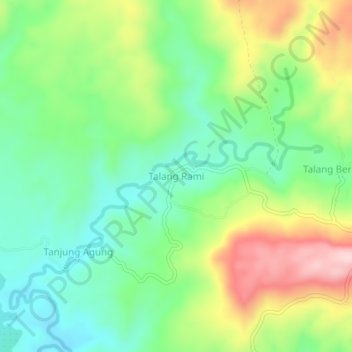
Name: Talang Rami topographic map, elevation, terrain.

Location: Talang Rami, Seluma, Bengkulu, Sumatra, Indonesia (-4.04395 102.54702 -4.00395 102.58702)

Average elevation: 123 m

Minimum elevation: 21 m

Maximum elevation: 298 m

Gear up for your next adventure:

🔥Camping Stove - Portable stoves to cook outdoors with ease
🧼Biodegradable Camp Soap - Environmentally friendly cleaning for gear and body
🩹Compact First Aid Kit - Pre-packed essentials for common trail injuries
🛏️Camping Sleeping Mat - Comfortable mats for sleeping outdoors
🥾Hiking Gaiters - Protect legs and shoes from mud, snow, and debris

As an Amazon Associate, this site earns from qualifying purchases at no extra cost to you.