
Make a donation
Gear up for your next adventure:
As an Amazon Associate, this site earns from qualifying purchases at no extra cost to you.
Palmerston North topographic map
Click on the map to display elevation.
Make a donation
Gear up for your next adventure:
As an Amazon Associate, this site earns from qualifying purchases at no extra cost to you.
Palmerston North
Although the land Palmerston North is situated on is bounded by the lofty Ruahine and Tararua ranges in the east and south respectively, the city has a predominantly flat appearance. The occasional rise in elevation occurs further away from the river and is especially pronounced in the north and northeast, and also on the south side of the river. The typical urban area elevation ranges between 20 and 40 metres (65–130 ft) above sea level.
Make a donation
Gear up for your next adventure:
As an Amazon Associate, this site earns from qualifying purchases at no extra cost to you.
About this map
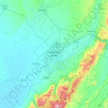
Name: Palmerston North topographic map, elevation, terrain.
Average elevation: 118 m
Minimum elevation: 3 m
Maximum elevation: 753 m
Make a donation
Gear up for your next adventure:
As an Amazon Associate, this site earns from qualifying purchases at no extra cost to you.