
Make a donation
Gear up for your next adventure:
As an Amazon Associate, this site earns from qualifying purchases at no extra cost to you.
Safford topographic map
Click on the map to display elevation.
Make a donation
Gear up for your next adventure:
As an Amazon Associate, this site earns from qualifying purchases at no extra cost to you.
Safford
The climate is cold semi-arid (Köppen: BSk) softened by the plateau rise (it receives enough rainfall not to fall into a cold desert, BWk). It is much hotter than most places in eastern Arizona due to its relatively low elevation of 2,953 feet (900 m) at the Agricultural Center where records are kept, and often reaches temperatures almost as hot as found in Phoenix. In January, the average high temperature is 60 °F or 15.6 °C with a low of 29 °F or −1.7 °C. In July, the average high temperature is 98 °F or 36.7 °C with a low of 68 °F or 20 °C. Annual precipitation averages around 9.8 inches (248.9 mm), and snowfall is exceptionally rare: the mean is around 0.8 inches (0.020 m) but the median is zero.
Make a donation
Gear up for your next adventure:
As an Amazon Associate, this site earns from qualifying purchases at no extra cost to you.
About this map
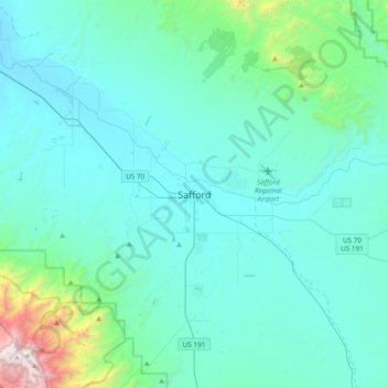
Name: Safford topographic map, elevation, terrain.
Location: Safford, Graham County, Arizona, 85548, United States (32.67395 -109.86758 32.99395 -109.54758)
Average elevation: 1,113 m
Minimum elevation: 839 m
Maximum elevation: 3,257 m
Make a donation
Gear up for your next adventure:
As an Amazon Associate, this site earns from qualifying purchases at no extra cost to you.