
Thank you for supporting this site ❤️
Make a donation
Make a donation
Gear up for your next adventure:
As an Amazon Associate, this site earns from qualifying purchases at no extra cost to you.
Cadaqués topographic map
Click on the map to display elevation.
Thank you for supporting this site ❤️
Make a donation
Make a donation
Gear up for your next adventure:
As an Amazon Associate, this site earns from qualifying purchases at no extra cost to you.
About this map
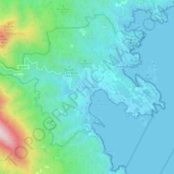
Name: Cadaqués topographic map, elevation, terrain.
Location: Cadaqués, Alto Ampurdán, Gerona, Cataluña, 17488, España (42.26935 3.25522 42.30935 3.29522)
Average elevation: 104 m
Minimum elevation: 0 m
Maximum elevation: 570 m
Thank you for supporting this site ❤️
Make a donation
Make a donation
Gear up for your next adventure:
As an Amazon Associate, this site earns from qualifying purchases at no extra cost to you.