Geolocate

Ramat Gan topographic map

Click on the map to display elevation.

About this map

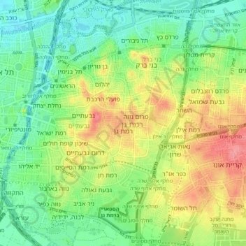
Name: Ramat Gan topographic map, elevation, terrain.

Location: Ramat Gan, Tel Aviv Subdistrict, Tel-Aviv District, Israel (32.03609 34.79912 32.10558 34.85459)

Average elevation: 35 m

Minimum elevation: 2 m

Maximum elevation: 85 m

Other topographic maps

Click on a map to view its topography, its elevation and its terrain.

Herzliya

Israel > Tel-Aviv District

Average elevation: 38 m

The Track Park

Israel > Tel-Aviv District > Tel Aviv

Average elevation: 15 m

Ayalon River

Israel > Tel-Aviv District > Tel Aviv

Average elevation: 23 m

Or Yehuda

Israel > Tel-Aviv District

Average elevation: 39 m

Herzliya

Israel > Tel-Aviv District

Average elevation: 38 m

Gear up for your next adventure:

🥾Hiking Shorts - Breathable shorts suitable for summer hikes
🧥Waterproof Pants - Keep dry during rainy hiking conditions
🎒Hiking Daypack - Lightweight and durable backpacks for day trips and excursions
🚲Bike Repair Kit - Essential tools for on-trail mechanical issues
🥾Trail Running Shoes - Lightweight and durable shoes for trail running

As an Amazon Associate, this site earns from qualifying purchases at no extra cost to you.