
Make a donation
Gear up for your next adventure:
As an Amazon Associate, this site earns from qualifying purchases at no extra cost to you.
Basdorf topographic map
Click on the map to display elevation.
Make a donation
Gear up for your next adventure:
As an Amazon Associate, this site earns from qualifying purchases at no extra cost to you.
Basdorf
Basdorf befindet sich auf dem westlichen Teil der Barnim-Hochfläche, dem Niederbarnim. Die Höhe über Normalhöhennull (NHN) nimmt von Süd nach Nord leicht ab. Der höchste Punkt mit 69,3 Metern über NHN liegt an der südwestlichen Grenze zur Gemeinde Mühlenbecker Land im Landkreis Oberhavel. Mit 52,5 Metern über NHN ist der nordwestliche Grenzgraben zur Zühlsdorfer Siedlung Fuchswinkel, die auch zum Mühlenbecker Land gehört, der niedrigste Punkt des Ortes. Die Höhe der alten Ortsmitte an der Kirche beträgt 58 Meter, die des neuen Zentrums am Markt 64 Meter über NHN.
Make a donation
Gear up for your next adventure:
As an Amazon Associate, this site earns from qualifying purchases at no extra cost to you.
About this map
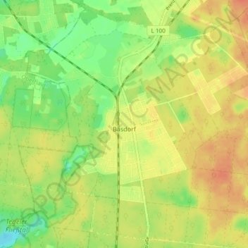
Name: Basdorf topographic map, elevation, terrain.
Location: Basdorf, Wandlitz, Barnim, Brandenburg, Deutschland (52.69262 13.40410 52.73440 13.47796)
Average elevation: 63 m
Minimum elevation: 41 m
Maximum elevation: 80 m
Make a donation
Gear up for your next adventure:
As an Amazon Associate, this site earns from qualifying purchases at no extra cost to you.
Other topographic maps
Click on a map to view its topography, its elevation and its terrain.