Geolocate

Kagoshima topographic map

Click on the map to display elevation.

About this map

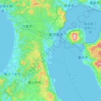
Name: Kagoshima topographic map, elevation, terrain.

Location: Kagoshima, Kagoshima Prefecture, 892-8677, Japan (31.29331 130.38673 31.75253 130.76631)

Average elevation: 110 m

Minimum elevation: -2 m

Maximum elevation: 1,094 m

Gear up for your next adventure:

🥾Hiking Shorts - Breathable shorts suitable for summer hikes
🔋Lithium AA Batteries - Long-lasting power that performs in extreme cold
🚑Survival Whistle - Signal for help across long distances in mountains
Bushcraft Tarp - Versatile emergency shelter or gear protection
🪑Ultralight Camping Stool - Compact seating for rest stops during long hikes

As an Amazon Associate, this site earns from qualifying purchases at no extra cost to you.