
Make a donation
Gear up for your next adventure:
As an Amazon Associate, this site earns from qualifying purchases at no extra cost to you.
Chez Martin topographic map
Click on the map to display elevation.
Make a donation
Gear up for your next adventure:
As an Amazon Associate, this site earns from qualifying purchases at no extra cost to you.
About this map
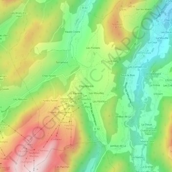
Name: Chez Martin topographic map, elevation, terrain.
Average elevation: 1,146 m
Minimum elevation: 818 m
Maximum elevation: 1,603 m
Make a donation
Gear up for your next adventure:
As an Amazon Associate, this site earns from qualifying purchases at no extra cost to you.
Other topographic maps
Click on a map to view its topography, its elevation and its terrain.
Lac de Vallon
France > Auvergne-Rhône-Alpes > Haute-Savoie > Bellevaux > La Basse Meille
Les 16 et 17 mars, le sous-préfet de Thonon, Georges Cathal, se rend sur place pour fournir les premiers secours aux sinistrés et superviser les évacuations, accompagné d’ingénieurs et d’ouvriers des Ponts et Chaussées, du chef départementale de la Légion française des combattants et de Germain…
Average elevation: 1,314 m