
Make a donation
Gear up for your next adventure:
As an Amazon Associate, this site earns from qualifying purchases at no extra cost to you.
Farnham topographic map
Click on the map to display elevation.
Make a donation
Gear up for your next adventure:
As an Amazon Associate, this site earns from qualifying purchases at no extra cost to you.
About this map
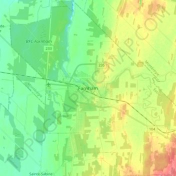
Name: Farnham topographic map, elevation, terrain.
Location: Farnham, Brome-Missisquoi, Quebec, Canada (45.22459 -73.04886 45.34193 -72.88203)
Average elevation: 63 m
Minimum elevation: 38 m
Maximum elevation: 105 m
Brome-Missisquoi trails, hiking, mountain biking, running and outdoor activities
Make a donation
Gear up for your next adventure:
As an Amazon Associate, this site earns from qualifying purchases at no extra cost to you.
Other topographic maps
Click on a map to view its topography, its elevation and its terrain.
Make a donation
Gear up for your next adventure:
As an Amazon Associate, this site earns from qualifying purchases at no extra cost to you.
Paradis-des-Chênes
Canada > Quebec > Brome-Missisquoi > Dunham > Paradis-des-Chênes
Average elevation: 167 m