Geolocate

Wesley Chapel topographic map

Click on the map to display elevation.

About this map

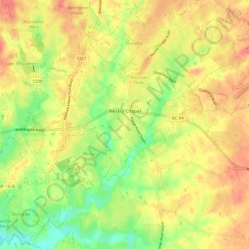
Name: Wesley Chapel topographic map, elevation, terrain.

Location: Wesley Chapel, Union County, North Carolina, United States (34.96368 -80.74207 35.04163 -80.64354)

Average elevation: 189 m

Minimum elevation: 153 m

Maximum elevation: 218 m

Other topographic maps

Click on a map to view its topography, its elevation and its terrain.

Cane Creek

United States > North Carolina > Union County

Average elevation: 177 m

Waxhaw

United States > North Carolina > Union County

Average elevation: 187 m

Trinity

United States > North Carolina > Union County

Average elevation: 190 m

Waxhaw

United States > North Carolina > Union County

Average elevation: 187 m

Waxhaw

United States > North Carolina > Union County

Average elevation: 187 m

Oakland

United States > North Carolina > Union County > Monroe

Average elevation: 177 m

Gear up for your next adventure:

🏃Hydration Running Vest - Carry water and maps close to your body for speed
Camping Coffee Maker - Brew fresh coffee anywhere on the topographic map
🛁Quick-Dry Microfiber Towel - Space-saving towel that dries rapidly on the move
🧥Thermal Layer - Insulating layer for cold outdoor conditions
Camping Tent - Weather-resistant tents suitable for 2 to 6 people

As an Amazon Associate, this site earns from qualifying purchases at no extra cost to you.