
Thank you for supporting this site ❤️
Make a donation
Make a donation
Gear up for your next adventure:
As an Amazon Associate, this site earns from qualifying purchases at no extra cost to you.
Maas topographic map
Click on the map to display elevation.
Thank you for supporting this site ❤️
Make a donation
Make a donation
Gear up for your next adventure:
As an Amazon Associate, this site earns from qualifying purchases at no extra cost to you.
About this map
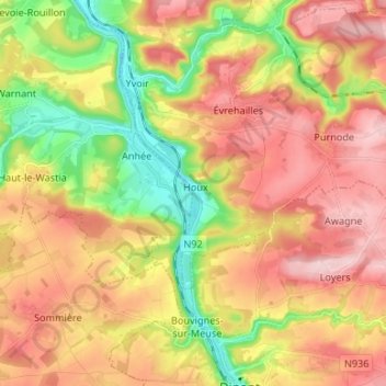
Name: Maas topographic map, elevation, terrain.
Location: Maas, Bouvignes-sur-Meuse, Dinant, Namen, Wallonië, België (50.25936 4.85636 50.34419 4.91227)
Average elevation: 194 m
Minimum elevation: 80 m
Maximum elevation: 294 m
Thank you for supporting this site ❤️
Make a donation
Make a donation
Gear up for your next adventure:
As an Amazon Associate, this site earns from qualifying purchases at no extra cost to you.