
Make a donation
Gear up for your next adventure:
As an Amazon Associate, this site earns from qualifying purchases at no extra cost to you.
Bad Köstritz topographic map
Click on the map to display elevation.
Make a donation
Gear up for your next adventure:
As an Amazon Associate, this site earns from qualifying purchases at no extra cost to you.
Bad Köstritz
Seit 1543 wurde das gewerbemäßige „Ausschenken“ von Bier der Fürstlich-Reußschen Bierbrauerei in der unteren Schenke (heute: Goldener Löwe) erlaubt. Der Dahlienzüchter Christian Deegen gründete 1826 eine Gärtnerei und leitete damit den Ruf des Ortes als Blumenstadt ein. Christian Glenck eröffnete 1831 auf der Pohlitzer Flur die Saline Heinrichshall, die allerdings 1909 ihre Produktion einstellte und mit der 1845 errichteten Chemischen Fabrik vereinigt wurde. Im Jahre 1845 richtete Adolf Sturm eine Badeanstalt ein, die 1865 durch Neubau eines Kurhauses und Umwandlung in eine Aktiengesellschaft bedeutend erweitert wurde. Das landwirtschaftliche Institut des Dr. Hans Settegast siedelte sich 1886 in Köstritz an. Daraus entwickelte sich mit einem 1903 errichteten Institutsgebäude die Höhere Gärtner-Lehranstalt, die 1943 für ein Lazarett ausgelagert und 1945 geschlossen wurde. An dieser Lehranstalt legte u. a. Ferdinand Tutenberg sein Examen ab.
Make a donation
Gear up for your next adventure:
As an Amazon Associate, this site earns from qualifying purchases at no extra cost to you.
About this map
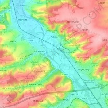
Name: Bad Köstritz topographic map, elevation, terrain.
Location: Bad Köstritz, Greiz, Thüringen, Deutschland (50.90049 11.94940 50.94865 12.04949)
Average elevation: 243 m
Minimum elevation: 174 m
Maximum elevation: 334 m
Make a donation
Gear up for your next adventure:
As an Amazon Associate, this site earns from qualifying purchases at no extra cost to you.
Other topographic maps
Click on a map to view its topography, its elevation and its terrain.
Make a donation
Gear up for your next adventure:
As an Amazon Associate, this site earns from qualifying purchases at no extra cost to you.
Sorge-Settendorf
Deutschland > Thüringen > Greiz > Mohlsdorf-Teichwolframsdorf
Average elevation: 355 m
Make a donation
Gear up for your next adventure:
As an Amazon Associate, this site earns from qualifying purchases at no extra cost to you.
Pöllwitz
Deutschland > Thüringen > Greiz
Pöllwitz liegt auf einer Höhe von 447 m über NN und besitzt einen Bahnhof an der Bahnstrecke Werdau–Weida–Mehltheuer, der jedoch seit dem 11. Dezember 2011 nicht mehr bedient wird. Sehenswert ist die historische Wehrkirche St. Nikolaus.
Average elevation: 435 m
Make a donation
Gear up for your next adventure:
As an Amazon Associate, this site earns from qualifying purchases at no extra cost to you.
Make a donation
Gear up for your next adventure:
As an Amazon Associate, this site earns from qualifying purchases at no extra cost to you.
Make a donation
Gear up for your next adventure:
As an Amazon Associate, this site earns from qualifying purchases at no extra cost to you.
Make a donation
Gear up for your next adventure:
As an Amazon Associate, this site earns from qualifying purchases at no extra cost to you.
Make a donation
Gear up for your next adventure:
As an Amazon Associate, this site earns from qualifying purchases at no extra cost to you.
Nitschareuth
Deutschland > Thüringen > Greiz
Nitschareuth liegt in einem langgestreckten Tal einer Hochfläche des Thüringer Schiefergebirges zwischen Daßlitz und Neumühle/Elster. Die Umgebung besteht aus Wiesen und Feldern. Die folgenden Anhöhen sind bewaldet.
Average elevation: 329 m
Make a donation
Gear up for your next adventure:
As an Amazon Associate, this site earns from qualifying purchases at no extra cost to you.
Bernsgrün
Deutschland > Thüringen > Greiz
Die Flur Bernsgrün ist über die Hälfte Grenze zum Land Sachsen. Die Gemarkung liegt im Thüringer Schiefergebirge auf einer Hochfläche umrahmt mit bewaldeten Hängen und Anhöhen und durchsetzt mit Fließgewässern. Die Landesstraße 2342 und die Bahnstrecke Werdau–Mehltheuer, an der Bernsgrün bis 2011…
Average elevation: 483 m
Dürrenberg
Deutschland > Thüringen > Greiz
Dürrenberg ist ein weilerartiges Straßendorf. Es befindet sich auf der ebenen Hochfläche des Dürrenberges, zwischen der Landesstraße 1075 und der Ortsverbindungsstraße nach Hartmannsdorf nordwestlich von Gera. Etwas südlicher vom Ort verläuft die Bundesautobahn 4. Zu dem nordöstlich liegenden Kernort…
Average elevation: 235 m