Geolocate

Mohope topographic map

Click on the map to display elevation.

About this map

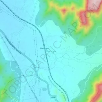
Name: Mohope topographic map, elevation, terrain.

Location: Mohope, Panvel Taluka, Raigad, Maharashtra, 410222, India (18.92159 73.17774 18.96159 73.21774)

Average elevation: 84 m

Minimum elevation: 17 m

Maximum elevation: 431 m

Other topographic maps

Click on a map to view its topography, its elevation and its terrain.

Central Park

India > Maharashtra > Panvel Taluka > Panvel

Average elevation: 25 m

Nere

India > Maharashtra > Panvel Taluka

Average elevation: 28 m

Gear up for your next adventure:

💧Filtered Water Bottle - Safe drinking water on the go
🥾Mountaineering Boots - Supportive boots for climbing and high-altitude hiking
🗺️Topographic Maps - Detailed maps to explore trails, mountains, and wilderness areas
🏃Hydration Running Vest - Carry water and maps close to your body for speed
🛶Waterproof Dry Bags - Keep electronics and clothes dry during river crossings

As an Amazon Associate, this site earns from qualifying purchases at no extra cost to you.