Rochefort-en-Terre topographic map
Interactive map
Click on the map to display elevation.
About this map
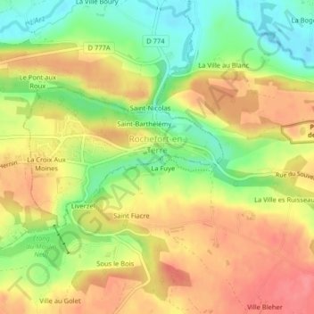
Name: Rochefort-en-Terre topographic map, elevation, terrain.
Average elevation: 55 m
Minimum elevation: 12 m
Maximum elevation: 91 m

Click on the map to display elevation.
Name: Rochefort-en-Terre topographic map, elevation, terrain.
Average elevation: 55 m
Minimum elevation: 12 m
Maximum elevation: 91 m