
Make a donation
Gear up for your next adventure:
As an Amazon Associate, this site earns from qualifying purchases at no extra cost to you.
Pendoworejo topographic map
Click on the map to display elevation.
Make a donation
Gear up for your next adventure:
As an Amazon Associate, this site earns from qualifying purchases at no extra cost to you.
About this map
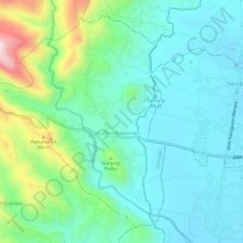
Name: Pendoworejo topographic map, elevation, terrain.
Average elevation: 193 m
Minimum elevation: 82 m
Maximum elevation: 553 m
Make a donation
Gear up for your next adventure:
As an Amazon Associate, this site earns from qualifying purchases at no extra cost to you.
Other topographic maps
Click on a map to view its topography, its elevation and its terrain.
Kelurahan Ngargosari
Indonesia > Special Region of Yogyakarta > Kulon Progo > Ngargosari
Average elevation: 615 m
Make a donation
Gear up for your next adventure:
As an Amazon Associate, this site earns from qualifying purchases at no extra cost to you.
Waduk Sermo
Indonesia > Special Region of Yogyakarta > Kulon Progo > Hargowilis
Average elevation: 171 m