
Thank you for supporting this site ❤️
Make a donation
Make a donation
Gear up for your next adventure:
As an Amazon Associate, this site earns from qualifying purchases at no extra cost to you.
Sullivan topographic map
Click on the map to display elevation.
Thank you for supporting this site ❤️
Make a donation
Make a donation
Gear up for your next adventure:
As an Amazon Associate, this site earns from qualifying purchases at no extra cost to you.
About this map
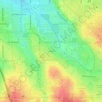
Name: Sullivan topographic map, elevation, terrain.
Location: Sullivan, Arapahoe County, Colorado, 80231, United States (39.65134 -104.91774 39.69134 -104.87774)
Average elevation: 1,672 m
Minimum elevation: 1,643 m
Maximum elevation: 1,704 m
Thank you for supporting this site ❤️
Make a donation
Make a donation
Gear up for your next adventure:
As an Amazon Associate, this site earns from qualifying purchases at no extra cost to you.