Geolocate

Hassela topographic map

Click on the map to display elevation.

About this map

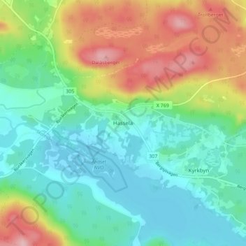
Name: Hassela topographic map, elevation, terrain.

Location: Hassela, Nordanstigs kommun, Gävleborg County, 829 98, Sweden (62.08826 16.69147 62.12826 16.73147)

Average elevation: 178 m

Minimum elevation: 118 m

Maximum elevation: 299 m

Other topographic maps

Click on a map to view its topography, its elevation and its terrain.

Gran

Sweden > Gävleborg County > Gnarp District

Average elevation: 0 m

Ljusdals kommun

Sweden > Gävleborg County

Average elevation: 315 m

Disan

Sweden > Gävleborg County

Average elevation: 43 m

Hamra

Sweden > Gävleborg County

Average elevation: 437 m

Hamra

Sweden > Gävleborg County

Average elevation: 437 m

Hamra

Sweden > Gävleborg County

Average elevation: 437 m

Söderhamns kommun

Sweden > Gävleborg County

Average elevation: 67 m

Gnarp District

Sweden > Gävleborg County

Average elevation: 32 m

Hudiksvalls kommun

Sweden > Gävleborg County

Average elevation: 95 m

Gävle kommun

Sweden > Gävleborg County

Average elevation: 61 m

Gävle

Sweden > Gävleborg County

Average elevation: 28 m

Ovanåkers kommun

Sweden > Gävleborg County

Average elevation: 269 m

Hofors kommun

Sweden > Gävleborg County

Average elevation: 147 m

Gear up for your next adventure:

Backpacking Tent - Lightweight tent for long-distance hiking trips
Lightweight Camping Tent - Portable shelter optimized for Canadian backcountry camping
🐕Hiking Dog Pack - Let your canine companion carry their own water and food
🔦LED Headtorch - Bright and durable light for night activities
🥫Freeze-Dried Meals - Lightweight, high-calorie nutrition for multi-day treks

As an Amazon Associate, this site earns from qualifying purchases at no extra cost to you.