Geolocate

Pulga topographic map

Click on the map to display elevation.

About this map

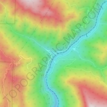
Name: Pulga topographic map, elevation, terrain.

Location: Pulga, Butte County, California, 95980, United States (39.78294 -121.46858 39.82294 -121.42858)

Average elevation: 750 m

Minimum elevation: 370 m

Maximum elevation: 1,200 m

Other topographic maps

Click on a map to view its topography, its elevation and its terrain.

Oroville Dam

United States > California > Butte County

Average elevation: 226 m

Butte Creek

United States > California > Butte County

Average elevation: 1,601 m

Oroville East

United States > California > Butte County

Average elevation: 246 m

Alumni Glen

United States > California > Butte County > Chico

Average elevation: 61 m

Durham

United States > California > Butte County > Durham

Average elevation: 51 m

Palermo

United States > California > Butte County

Average elevation: 90 m

Thermalito

United States > California > Butte County

Average elevation: 47 m

Gear up for your next adventure:

🚲Heavy Duty Bike Lock - Secure your bike at the trailhead or during stops
🌬️Windproof Camp Stove - Efficient cooking even on exposed mountain peaks
🧣Merino Neck Gaiter - Protects against wind, sun, and cold at high altitudes
🧥Ultralight Puffy Jacket - Maximum warmth that packs down to the size of an orange
🥾Mountain Trail Shoes - High-traction shoes for mountain trails

As an Amazon Associate, this site earns from qualifying purchases at no extra cost to you.