
Perth topographic map
Click on the map to display elevation.
About this map
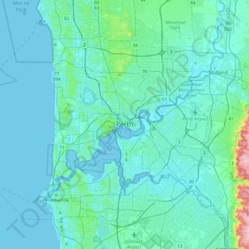
Name: Perth topographic map, elevation, terrain.
Location: Perth, Western Australia, 6000, Australia (-32.11590 115.70058 -31.79590 116.02058)
Average elevation: 26 m
Minimum elevation: -2 m
Maximum elevation: 288 m
Other topographic maps
Click on a map to view its topography, its elevation and its terrain.
Henley Brook
Henley Brook is situated on the flood plains of the Swan River, with regularly occurring seasonal floods. Two ephemeral streams from the river - Henley Brook and St. Leonard's Creek - traverse the suburb. Henley Brook is in the north-east near Brockman Street, while St Leonards Creek traverses the centre of…
Average elevation: 28 m