Geolocate

Storvreta topographic map

Click on the map to display elevation.

About this map

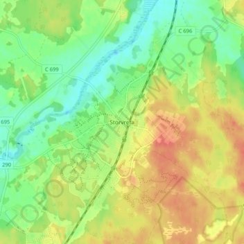
Name: Storvreta topographic map, elevation, terrain.

Location: Storvreta, Uppsala kommun, Uppsala County, 743 30, Sweden (59.93939 17.68569 59.97939 17.72569)

Average elevation: 34 m

Minimum elevation: 13 m

Maximum elevation: 55 m

Other topographic maps

Click on a map to view its topography, its elevation and its terrain.

Östhammars kommun

Sweden > Uppsala County

Average elevation: 10 m

Gear up for your next adventure:

🥤Collapsible Travel Cup - Saves space and weight in your mess kit
🧴Bear Spray Holster - Quick-access carry for essential Canadian wilderness safety
🦯Trekking Poles - Reduced impact on joints for steep topographic climbs
💡LED Headlamp - Hands-free illumination for night hiking and camping
🛌Down Sleeping Bag - Superior warmth-to-weight ratio for cold nights

As an Amazon Associate, this site earns from qualifying purchases at no extra cost to you.