
Make a donation
Gear up for your next adventure:
As an Amazon Associate, this site earns from qualifying purchases at no extra cost to you.
Écaussinnes topographic map
Click on the map to display elevation.
Make a donation
Gear up for your next adventure:
As an Amazon Associate, this site earns from qualifying purchases at no extra cost to you.
About this map
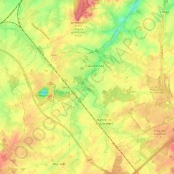
Name: Écaussinnes topographic map, elevation, terrain.
Location: Écaussinnes, Zinnik, Henegouwen, Wallonië, België (50.52495 4.12335 50.59665 4.22945)
Average elevation: 110 m
Minimum elevation: 59 m
Maximum elevation: 153 m
Make a donation
Gear up for your next adventure:
As an Amazon Associate, this site earns from qualifying purchases at no extra cost to you.
Other topographic maps
Click on a map to view its topography, its elevation and its terrain.
Louvignies
België > Henegouwen > Zinnik > Zinnik > Chaussée-Notre-Dame-Louvignies
Average elevation: 87 m
Make a donation
Gear up for your next adventure:
As an Amazon Associate, this site earns from qualifying purchases at no extra cost to you.