Geolocate

Melfort topographic map

Click on the map to display elevation.

About this map

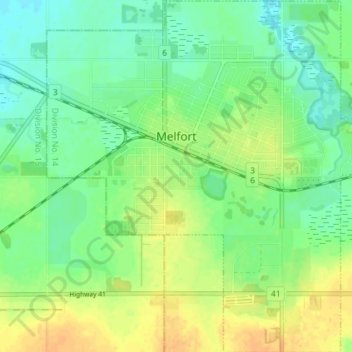
Name: Melfort topographic map, elevation, terrain.

Location: Melfort, Division No. 14, Saskatchewan, Canada (52.83445 -104.64029 52.87823 -104.56770)

Average elevation: 462 m

Minimum elevation: 449 m

Maximum elevation: 478 m

Division No. 14 trails, hiking, mountain biking, running and outdoor activities

Other topographic maps

Click on a map to view its topography, its elevation and its terrain.

Garrick

Canada > Saskatchewan > Division No. 14

Average elevation: 429 m

Gear up for your next adventure:

💧Collapsible Water Bottle - Space-saving water bottle for outdoor activities
💧Hydration Pack - Hands-free hydration system for long hikes
Bushcraft Tarp - Versatile emergency shelter or gear protection
🛏️Camping Sleeping Mat - Comfortable mats for sleeping outdoors
🔋Lithium AA Batteries - Long-lasting power that performs in extreme cold

As an Amazon Associate, this site earns from qualifying purchases at no extra cost to you.