
Puducherry Taluk topographic map
Interactive map
Click on the map to display elevation.
About this map
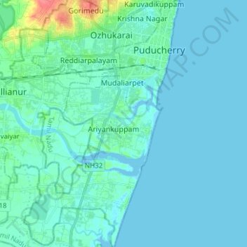
Name: Puducherry Taluk topographic map, elevation, terrain.
Location: Puducherry Taluk, Puducherry district, Puducherry, India (11.83638 79.76216 11.95864 79.84102)
Average elevation: 6 m
Minimum elevation: -5 m
Maximum elevation: 54 m
Other topographic maps
Click on a map to view its topography, its elevation and its terrain.
Puducherry
India > Puducherry > Puducherry Taluk
Puducherry, Puducherry Taluk, Puducherry District, Puducherry, 605001, India
Average elevation: 10 m
Bahour
India > Puducherry > Bahour Taluk
Bahour, Bahour Taluk, Puducherry District, Puducherry, 607402, India
Average elevation: 9 m
Kalapet
India > Puducherry > Ozhukarai Taluk
Kalapet, Ozhukarai Taluk, Puducherry District, Puducherry, 605014, India
Average elevation: 14 m
Oulgaret
India > Puducherry > Ozhukarai Taluk > Oulgaret
Oulgaret, Ozhukarai Taluk, Puducherry district, Puducherry, 605005, India
Average elevation: 18 m
Bahour Taluk
Bahour Taluk, Puducherry District, Puducherry, India
Average elevation: 7 m
Yanam
India > Puducherry > Yanam Taluk
Yanam, Yanam Taluk, Yanam District, Puducherry, 533464, India
Average elevation: 5 m