
Le Crest topographic map
Interactive map
Click on the map to display elevation.
About this map
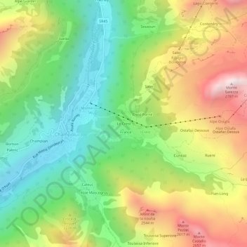
Name: Le Crest topographic map, elevation, terrain.
Location: Le Crest, Champoluc, Ayas, Vallée d'Aoste, 11020, Italie (45.81337 7.71910 45.85337 7.75910)
Average elevation: 2,052 m
Minimum elevation: 1,538 m
Maximum elevation: 2,787 m
Other topographic maps
Click on a map to view its topography, its elevation and its terrain.
Champlan
Italie > Vallée d'Aoste > Ayas > Champoluc
Champlan, Champoluc, Ayas, Vallée d'Aoste, 11020, Italie
Average elevation: 1,949 m