
Make a donation
Gear up for your next adventure:
As an Amazon Associate, this site earns from qualifying purchases at no extra cost to you.
Craponne topographic map
Click on the map to display elevation.
Make a donation
Gear up for your next adventure:
As an Amazon Associate, this site earns from qualifying purchases at no extra cost to you.
About this map
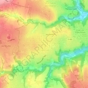
Name: Craponne topographic map, elevation, terrain.
Average elevation: 277 m
Minimum elevation: 211 m
Maximum elevation: 329 m
Make a donation
Gear up for your next adventure:
As an Amazon Associate, this site earns from qualifying purchases at no extra cost to you.
Other topographic maps
Click on a map to view its topography, its elevation and its terrain.
Parc Sergent Blandan
France > Auvergne-Rhône-Alpes > Métropole de Lyon > Lyon
Average elevation: 174 m
Parc de la Tête d'Or
France > Auvergne-Rhône-Alpes > Métropole de Lyon > Lyon
Average elevation: 189 m
Les Aqueducs de Champvert
France > Auvergne-Rhône-Alpes > Métropole de Lyon > Lyon
Average elevation: 236 m
Island
France > Auvergne-Rhône-Alpes > Métropole de Lyon > Collonges-au-Mont-d'Or
Average elevation: 218 m
Make a donation
Gear up for your next adventure:
As an Amazon Associate, this site earns from qualifying purchases at no extra cost to you.