Geolocate

Rignac topographic map

Click on the map to display elevation.

About this map
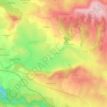
Name: Rignac topographic map, elevation, terrain.

Location: Rignac, Gourdon, Lot, Occitania, Metropolitan France, 46500, France (44.78940 1.67165 44.82445 1.72611)

Average elevation: 328 m

Minimum elevation: 198 m

Maximum elevation: 422 m

Other topographic maps

Click on a map to view its topography, its elevation and its terrain.
Lostange

France > Occitania > Lot > Linac

Average elevation: 326 m

Pech de Fos

France > Occitania > Lot > Cieurac

Average elevation: 247 m

Mas de la croix

France > Occitania > Lot > Béduer

Average elevation: 283 m

Gear up for your next adventure:

🔦UV Flashlight - Detect minerals or specific insects in the dark
🍽️Titanium Camping Spork - Ultralight and indestructible eating utensil
🏃Hydration Running Vest - Carry water and maps close to your body for speed
☕Camping Coffee Maker - Brew fresh coffee anywhere on the topographic map
👟Leg Gaiters - Keep debris, mud, and snow out of your boots

As an Amazon Associate, this site earns from qualifying purchases at no extra cost to you.