Siniloan topographic map
Click on the map to display elevation.
Siniloan
Buruwisan falls is located in Siniloan Laguna which is around eighty kilometers east of Manila. To get there we had to cross the long winding roads of Teresa and Bugarin to Mabitac. By public transport Take UV express vans bound to Tanay market in Starmall-Shaw terminal (P70). Then in Tanay market, ride a jeepney going to Siniloan (P47). In Siniloan, take a tricycle to Brgy Macatad (Mt Romelo's jumpoff) (P20). By private transport From Manila, Take the east-bound lane of Ortigas Avenue going to Antipolo. Then take the Manila-east route going to Famy, Laguna. From here jump off is less than 10 minutes away via Siniloan-Famy-Real-Infanta Road. Major Jump-off: Barangay Macatad, �Elevation: 300 MASL�Days required / hours to summit: 1 day, 2–3 hours�Specs: Minor Climb, Difficulty 2/9, Trail Class 1�Features: Waterfalls, rain forest
About this map
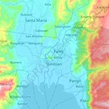
Name: Siniloan topographic map, elevation, terrain.
Location: Siniloan, Laguna, Calabarzon, 4019, Philippines (14.37150 121.43183 14.49245 121.51530)
Average elevation: 120 m
Minimum elevation: -5 m
Maximum elevation: 545 m
Other topographic maps
Click on a map to view its topography, its elevation and its terrain.